Change is inevitable. It cannot be avoided because of the growing demands for land. Land is an important factor for a strong country and nation because it supports life and any other activites. Land is needed for residence, commercial and industrial activities. Someone has to do something to make a change to create more space and land for businesses and residence. Moreover, the birth rate is increasing rapidly and more babies and newborn are being born everyday. The birth rates are rising and by 2050, the population of the world would be thrice or even four times the birth rates today! This might be a shocking news to behold but this is the truth, its is reality and there must be some courses of action for the rising demand of land. Land is a scarce resource and it should be used be preserved. Therefore, the governement have decided to increase the price per unit area of land. The price mechanism controls the allocation of land uses. Land is very valuable in cities like singapore as competition among different land uses is intense. As a result of the high land value, we usually find activities that can generate high income or profits in the city centre. In this case here, the people who stand to gain are the wealthier people as they can afford the expensive housing and residential estates near the city. The shop owners and shopkeepers in the shopping centres also stand to gain as the residential estates are near to their shops. The residents living near the shops can patronise them conveniently and easily. The governement also stands to gain as the profits are higher so more amount of taxes are paid to them.
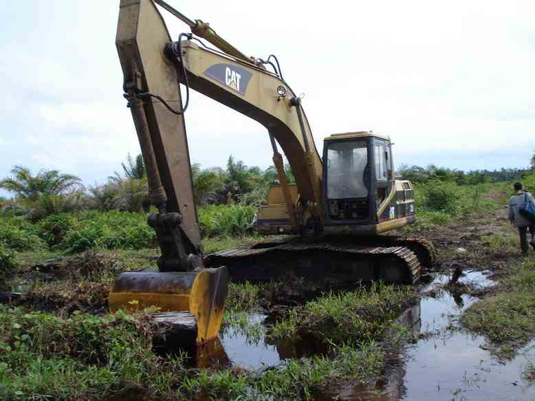
For land clearance, there has to be some kind of sacrifice. There are signs of deforestation that can be found in some countries. Its is happen quickly. In 1850, there were nearly 20 million square kilometres of rainforest in the world but by 2005, only 9 to 12 million square kilometrees of rainforests remain. There are people who would stand to gain. The commercial logging companies would earn a lot. Furniture and paper shops and shops selling wood and timber would also gain as their profit would increase when their stocks increase. Cattle ranches would also tend to win as large areas of land are needed for the rearing of cattles. Herds of cattles are raised for beef and exported to many countries. Many species of plants and animals would be at the losing side as clearing the forests will have an impact on them. They would lose their natural habitat and would have nowhere to seek shelter and no food to fill their hunger. People that are responsible for this change would be the selfish humans who wants the land for themselves only. Besides, there would be more global warming and that means life would end faster and thus, all of us would be at the losing end.
For empoldering, the ones at the winning end would be the farmers. They would benefit most from this reclamation plan as they can control the water supply in their farms and didn't have to rely on the rain neither do they have to fight the floodings from the sea. The ones at the losing end are the dyke builders battling endlessly against the enroaching sea.
For draining swamps, those that benefit are the farmers as more land are made for farmland. They also have irrigation from the excess water in the reclaimed land. This way, their crops would have enough water and grow healthier.
For urban land use, the governement and house agents would gain as there are many space to build more buildings and thus, there are more units for people to buy and rent. Thus, their business would naturally increase. The ones at the losing end would be the residents living in HDB flats designed by the government as more land is needed for building other things. Therefore, the buildings are built at such a close range from each other that even a slight tinge of noise could be heard. Would you want to hear your neighbour singing in the middle of the night and affect your sleep? Would you want to hear your neighbours coughing and making disgusting noises when you have your breakfast? Would you want nasty and pungent smells of all sorts to drift in your living or study room when you have guests to entertain and when you are doing your homework? I am very sure that your replies would be negative for all the questions raised. Therefore, there are disadvantages of living near. Of course, there are also advantages. They would be more neighbours to care for you and be on the lookout for you when you are in trouble. If you fall ill and there is nobody at home, your neighbours would be there for you. If you suddenly got kidnapped or robbed, your neighbours would always be on the watch.
Therefore, I have concluded that change is inevitable. Land is scarce and we have to think of ways to improve the situation but although the change cannot be avoidable, we can always make slight modifications and changes to make the situation better. If there is a will, there is always a way! If all of us take a step back and brainstorm to improve the situation by a little, soon, the whole thing would be improving DRASTICALLY!
Sunday, March 28, 2010
LIST OF VIDEOS FOR FURTHER VIEWING!!
Hello people, these videos are for further viewing and knowledge. All these are made to let you have a better understanding of the topics of how to overcome the rising demand of land.
LAND CLEARANCE: DEFORESTAION
http://www.youtube.com/watch?v=mZ7n4c7xyw8
http://www.youtube.com/watch?v=SAS0IqVqtG4
EQUIPMENT FOR LAND CLEARANCE
http://www.youtube.com/watch?v=iSLoCyPcC4s
http://www.youtube.com/watch?v=GHXJ_kcImzQ
VIDEOS YOU HAVE TO VIEW!!
http://www.youtube.com/watch?v=BLnjBFmLPQs
http://www.youtube.com/watch?v=cOQ5g2GPVj8
EMPOLDERING
http://www.youtube.com/watch?v=VB0Nmdd2P8g
land reclamation
http://www.youtube.com/watch?v=SqykNIr2zZY
Restoring Derelict Land


In Singapore, there were mining activities in the past, as seen in the disused granite quarries in Bukit Timah, Bukit Batok and Pulau Ubin. We can also imagine what a mining activity is like by looking at the digging done in a construction site. As excavations proceed at the site, the bare soil and rocks beneath the land surface resemble that of a quarry or a mine. When mining operations cease, restorations and works are necessary. This is becauserain would wash the soilheaps down the slope, causing more erosion along the way. A heavy downpour may even cause landslides. At times, mining pools are formed by rainwater gathering in the disused quarries.
DERELICT land can be made useful if its reclaimed. An example of derelict land is a disused quarry. The mining pools in such quarries can be:
i) filled up completely with non-toxic waste
ii) treated with acidic substances like gypsum
iii) replanted with vegetation to protect the soil from wind and rain to prevent furthur soil erosion
iv) filled with water to form lakes
Some mining pools that have been made into venues for recreational purposes are Taiping Lake in Perak, Malaysia and Little Guilin in Bukit Batok, Singapore. Most recently in 2006, the Selangor State Government in Malaysia is turning former mining pools into fishing venues.
Draining Swamps

Swamps were historically often drained to provide additional land for agriculture, and to reduce the threat of diseases born by swamp insects and similar animals. Swamps were generally seen as useless and even dangerous. This practice of swamp draining is nowadays seen as a destruction of a very valuable ecological habitat type of which large tracts have already disappeared in many countries.
A coastal swamp is always flooded whenever the tide rises. Similarly, swamps that are found inland become waterlogged whenever nearby rivers overflow their banks during the wet seasons. The role of wetlands and swamps is not limited to the retention of water. Wetlands act like natural sponges as they capture surface runoff water and bring it back to the surface slowly, preventingseriou water level control problems. They also limit soil erosion. The plants take root in them and absorb the effects of the wind and slow the current along the shore as well as sudden water level changes.
Dykes are built along the coast to keep the sea water out of the former swamps. Freshwater is brought in from a river through a network of canals. Excess water in the reclaimed land us removed by a system of drains. In this way, more land is made available for farmland. One example of land reclamation through draining swamps is the Tanjong Karang Land Reclamation Scheme in Selangor, Malaysia.
Advantages and Disadvantages of Empoldering

Advantages:
# Its ensures security to crops and livestock
# Better conditions for new crops (boro rice and betel leaves)
# Improved all year round road network leading to access to markets, new avenues of employment such as transport and higher enrollment/attendance in schools for improved education for the people which would in turn affect the improvement of the economy and the education level of the citizens.
Disadvantages:
> Restricted water flow in the internal channels leading to stagnant water and breeding grounds for mosquitoes and mozzies. Thus, dengue fever would then occur and will lead to the increase of people seeking medical help. Till then, the hospitals and clinics would not have enough medical equipment.
> Dry season scarcity of water, particularly for domestic use, and pollution of the little water that is available.
>Loss of capture fisheries.
Saturday, March 27, 2010
Land reclamation in other countries


Empoldering
In some countries in the Netherlands, much of the land is below sea level. In order to drain the waterlogged land for agriculture and other purposes, people resort to land reclamation by building dykes. Dykes are raised embarkments. This method is called empoldering, and the land created is called polder. For more than 300 years, the Dutch have been turning marshlands, lakes and seas into farmlands through empoldering,
Empoldering refers to the creation of polders.
A polder is a piece of land lying in a low lying area reclaimed froma body of water by building dykes and by drainage.
Empoldering can be carried out in coastal and inland areas such as lakes.
Features of Polders
-Polders are enclosed by dykes to keep out the sea.
-To prevent the polders from being waterlogged, they are managed by drainage canals and pumps.
Dykes protect the polder from erosion.
Drainage canals carry away excess water from the polders.
Method of empoldering
1) A dyke is constructed around the area to be reclaimed to keep water from coming in. The water in the reclaimed area is replaced by freshwater.
2)Secondly, pumps and drainage canals are used to drain the area.
3)Thirdly, reeds are sown to help to soil absorb excess water from the soil.
4) Three years later, the reeds are burnt. Drainage pipes are constructed. Ploughs are used to mix the fertile ash into the soil.
5) After around 15 years, the polder can still be used for growing crops, building houses and constructing roads.
Careful land use planning is necessary before embarking on empoldering products as there is a need to have a balance between making the best use of land and causing the least harm to the environment.
Tuesday, March 23, 2010
Advantages And Disadvantages of Land reclamation
Land reclamation will definitely increase land area for a certain country. With more land, more buildings and infrastructure can be built, and also for other reasons. In Singapore, land reclamation is intense, and reclaimed land is everywhere. It is used to build Marina Bay, which is the location of Integrated Resorts, financial centers and the Singapore Flyer, a ferris wheel.
The world-famous Changi Airport is also built on reclaimed land. One of the seaports is also located on reclaimed land. The entire "East Coast Park", which consists of a park, a man-made beach and housing, is also situated on Singapore's largest scale reclaimed land. Reclaimed land is also present on neighboring islands for housing, industry and many more purposes.
Netherlands has also reclaimed a lot of land to prevent flooding. Netherlands is actually situated below water level, thus prone to flooding. These lands are called polders, where the land is also below water level. Almost 20% of its land is reclaimed land! As the saying goes, "God has created the world, but the Dutch created Netherlands".
Dubai reclaims both land and artificial islands. Examples are the Palm Islands, The World, The Universe and the island which Burj al-Arab is situated on. The Palm Islands are for beauty, as well as housing. The Palm Islands can be seen for space, and is definitely a spectacular view. The Palm Deira will be the largest man-made island when completed. This has definitely increased Dubai's land area, as well as its coastal perimeter. The Dubai Waterfront, situated beside Palm Jebel Ali, will be the largest waterfront and largest man-made development in the world.
Artificial islands, as mentioned before, are also part of land reclamation. The Kansai International Airport in Osaka, Japan, and the Hong Kong International Airport are built on artificial islands off the coast of the main country. Artificial islands cost a bomb to build, and are very risky.
Of course, there are also many other examples, such as the Tokyo Bay area and Rio de Janeiro.
However, as there are advantages, there are also disadvantages too. Land reclamation can be damaging to corals and marine life. Corals are usually moved to another place when land is to be reclaimed. The corals might not be able to survive in that certain habitat, and thus die out. In some countries, where the project is large-scale, they do not even bother to re-plant the corals elsewhere, instead just reclaim the land on their habitat, causing them to die out immediately. Marine life, such as fishes, might not have enough food after the underwater plantations are destroyed due to reclamation of land. This applies to the food chain. The waters might also be polluted from the soil used to reclaim land, causing the fishes to die and blocking out sunlight, depriving the underwater plants of growth. Marine habitats are also destroyed, as mentioned earlier; therefore, the marine creatures would be forced to move to another new habitat. Some might not be able to adapt, and thus die out. Some would just die without even finding a new habitat, as they cannot move long distances in water. Of course, the reasons and examples look tempting to us humans, but marine life is life too! We should try to protect is as much as possible, instead of just focusing on the advantages.
Land Reclamation in Singapore (Part ll)


Singapore also has to overcome the constraints of limited land space. Large-scale land reclamation by landfill has been carried out in different parts of Singapore since the 1960s. Land reclamation took place mainly at the South-East, South-West and the North-East of Singapore.
Land reclamation in Singapore started as early as 1820. Swamps along the Singapore river were filled to provide land for early settlers. These were small land reclamation projects. In contrast, land reclamation projects after 1960 were large enough to make an impact on the growth of Singapore's land area. In particular, the reclamation of mangrove swampsin Jurong in 1961 spearheaded Singapore's industrialisation plans and other land reclamation projects. In 1963, the land reclamation project in Bedok provided space to build new homes for Singaporeans.
Singapore's land area grew from 581.5 square kilometres in 1960 to 699 square kilometres in 2004. This means that its area increased by 117.5 square kilometres(20.2%) in 44 years. The Urban Redevelopment Authority (URA) projects a land shortage of 40 square kilometres when the population grows from 5.5 million. If the economic growth continues at the present pace, the government will need more land for housing and recreational facilities. More land is also needed for rapid economic growth. This included expanding commercial and industrial activities, and developing infrastructure such as road, expressways, the MRT and LRT systems, the port and airport facilities. These are examples of land reclamation by landfill method put to good use.
Besides reclaiming land by filling in the swamps, Singapore also reclaimed land from the sea using the landfill method, for example, Marina City and Pulau Semakau. To reclaim land from the sea, dykes must be constructed in shallow parts of the sea to prevent the seawater from entering the area to be reclaimed. The area is then filled with sand, rock or soil. The sand can be obtained from the seabed or imported from other countries, while the rocks and soil can be obtained from the hills nearby.
Monday, March 22, 2010
Land Reclamation In Singapore

Reasons for Land Reclamation
Large-scale land reclamation has been undertaken in different parts of Singapore since the 1960s. This is necessary because of
=the small size of the country (total area being about 581.5km square prior to 1960) and
the rising demand for more land as the population increases.
=More land has been made available for
building more homes in private and public housing estates and recreational facilities for the growing population, and
expanding commercial and industrial activities and transport needs, the latest of which include roads, expressways, the Mass Rapid Transit System, the port and airport facilities.
By 1990, the total land area of Singapore was 633km square. This was an increase of 51.5km square, which made up 8.9% the total land area. With continuing land reclamation, land area in Singapore will increase by about another 100km square by the year 2030. There are, however, constraints as to how much more land the country can reclaim. Two limiting factors have to be considered.
Land reclamation works in the past used to be carried out from depths of 5-10m. Today, reclamation works have to venture into deeper waters of 15m or so and this will incur much higher costs.
It is also not so viable to pursue pushing reclamation further offshore because there is the competing need to maintain the sealanes and provide new and larger ports for the bigger ships to anchor in Singapore's limited sea space.
Land Reclamation Agencies
Other than the land reclamation of the offshore islands of Pulau Bukum, Pulau Bukum Kechil, Pulau Ular and Pulau Ayer Chawan by two private oil companies, land reclamation is undertaken by three public agencies in Singapore. They are
>Housing and Development Board (HDB)
>Jurong Town Corporation (JTC)
>PSA Corporation
Among some of the future large-scale reclamation works are
>>a long island off the east coast and the length of which will stretch from near Marina East to Changi for waterfront housing and recreational development and roads,
>>Pulau Tekong and Pulau Ubin for housing and some industrial development when Singapores population exceeds four million and
Pulau Serangoon and Punggol Point which will be reclaimed for quality housing.
Land reclamation has modified the coastline of Singapore, extending it seawards, especially on the eastern, north-eastern and western parts of the island, and changing it quite beyong recognition. Large coastal areas have also been starightened by the building dykes across estuaries, particularly in the west coast across the estuaries of Tengeh, Poyan, Murai and Sarimbun. Many offshore islands have become larger. Future reclamation will add more changes to the configuration of Singapore.
Method of Land Reclamation
The landfill mothod is used to reclaim land from the coast and the swamps in Singapore. It is also used in reclamation works involving the merging of islands. One such project is the amalgamation of Pulau Sakra and Pulau Bakau into one big island called Pulau Sakara, which is ten times the size of the two former islands.
In the early years, the fill materials evacuated from the hills in Bedok, Siglap, Tampines and Jurong were used for filling the reclamation areas. In recent years, sea sand obtained from the seabed is the main source of fill materials for reclamation. The reclamation contractors import the sea sand from the neighbouring countries such as Indonesia.
Friday, March 19, 2010
Deforestation


Singapore has lost up to 73 percent of its plants and animals over the last two centuries, new data reveals. According to one of the most robust studies of tropical extinctions yet attempted, more than one- fifth of Southeast Asia's total species could follow suit by the end of the century, if land degradation continues unabated
To further conservationists' woes, prospects for the remaining species are bleak. World Conservation Union (IUCN) figures estimate that 77 percent of the island's remaining butterflies, fish, birds, mammals, and other species are threatened. Deforestation for agriculture, rapid urban development, over-hunting, and even the shelling of nature reserves during World War II are all to blame, says a letter detailing the findings in the 24 July edition of the journal Nature.
Large areas of forests are cleared by commercial logging companies. The forests provide timber that can be made into various products such as paper and furniture for sale. Mordern equipment used to log the trees also speeds up the rate at which the trees are cut. However, we have to bear in mind that uncontrolled economic development accelerates deforestation. It causes damage to the land.
The forest is also cleared for agriculture purposes. Cattle ranchers need large areas of land for the rearing of cattles. Herds of cattle are raised for beef and exported to many countries. Plantation agriculture also requires large pieces of land. As such, large areaso of forests must be cleared for this type of farming
Advantages: When more forests and trees are cleared, there are more sufficient space for the buildings for factories, buildings and flats for commercial, industrial and residential purposes.
Disadvantages: The animals would lose their natural habitat and when many animals cannot adapt to their harsh surroundings, they would die in a rising number and many more endangered animals would then be extinct. The trees and shrubs that have been aiding our oxygen supply would mostly be chopped down. More air pollution would then occur.
EFFECTS OF DEFORESTATION:
Clearing the forest will have an impact on many species of plants and animals when their habitats are destroyed. Deforestation also brings about soil erosion and affects the hydrologic cycle. When there is less protection cover for the soil, soil erosion and soil leaching occur. The top soil which contains the soil nutrients will gradually lose its fertility. Fewere trees also mean a decrease in evapotranspiration. This in turn will result in a decrease in rainfall. Deforestation not only depletes forest resources but also contributes to the greenhouse effect. Trees take in carbon dioxide through the process of photosynthesis and give out oxygen. With forest vegetation, the carbon dioxide produced by fossil fuels can be reduced. With fewer trees, the Earth will be warmer.
Agricultural land use
Agriculture activities usually take place mainly in the rural areas. agriculture land use is the maximising of the use of arable land. The farmers need to do so in order to increase their crop produce for both subsistence and commercial purposes. Agriculture land use is similar to that of urban land use which can be found in Singapore or other large cities.

Terracing
The method of farming on steps cut on hillside is called terracing. This method increases the area of arable land. This method thus maximises the existing land use.In agriculture, a terrace is a leveled section of a hill cultivated area, designed as a method of soil conservation to slow or prevent the rapid surface runoff of irrigation water. Often such land is formed into multiple terraces, giving a stepped appearance. The human landscapes of rice cultivation in terraces that follow the natural contours of the escarpments like contour plowing is a classic feature of the island of Bali and the Banaue Rice Terraces in Benguet, Philippines. In Peru, the Inca made use of otherwise unusable slopes by drystone walling to create terraces. This form of land use is prevalent in many countries, and is used for crops requiring a lot of water, such as rice. Terraces are also easier for both mechanical and manual sowing and harvesting than a steep slope would be. Terracing slows down the speed of water and therefore allow more run-off to be sucked up by the soil.
Soil-less farming (method of hydroponics)


Hydroponic farms do not need soil to grow vegetables and other crops. By using this farming method, less land is needed moreover, the supply of food is not affected. This way, we can thus maximise the existing land use.Hydroponics is a method of growing plants using mineral nutrient solutions, in water, without soil. Terrestrial plants may be grown with their roots in the mineral nutrient solution only or in an inert medium, such as perlite, gravel, or mineral wool.
Researchers discovered in the 19th century that plants absorb essential mineral nutrients as inorganic ions in water. In natural conditions, soil acts as a mineral nutrient reservoir but the soil itself is not essential to plant growth. When the mineral nutrients in the soil dissolve in water, plant roots are able to absorb them. When the required mineral nutrients are introduced into a plant's water supply artificially, soil is no longer required for the plant to thrive. Almost any terrestrial plant will grow with hydroponics. Hydroponics is also a standard technique in biology research and teaching.
Researchers discovered in the 19th century that plants absorb essential mineral nutrients as inorganic ions in water. In natural conditions, soil acts as a mineral nutrient reservoir but the soil itself is not essential to plant growth. When the mineral nutrients in the soil dissolve in water, plant roots are able to absorb them. When the required mineral nutrients are introduced into a plant's water supply artificially, soil is no longer required for the plant to thrive. Almost any terrestrial plant will grow with hydroponics. Hydroponics is also a standard technique in biology research and teaching.
Irrigation 
 It helps to maximise existing land use. This particular method involves supplying water to areas that were formerly not suitable for cultivation, such as deserts or areas with seasonal or unreliable rainfall. Irrigation can also increase yields in existing farmlands by lengthening the growing seasons. Traditional methods include diverting water to the fields by simple canals. Its widely used in China and in South-East asian and African countries. Water comes from wells, rivers, lakes or tanks that store rainwater. Nowadays, perennial canals are built. These canals provide irrigation all year round. They are usually built in conjuction with large ddamn projects such as the Aswan High Dam Project which was built across the Nile River in Egypt. Sprinklers driven by electric pumps are also wideely used on modern farms to increase the efficiency of irrigation.

 It helps to maximise existing land use. This particular method involves supplying water to areas that were formerly not suitable for cultivation, such as deserts or areas with seasonal or unreliable rainfall. Irrigation can also increase yields in existing farmlands by lengthening the growing seasons. Traditional methods include diverting water to the fields by simple canals. Its widely used in China and in South-East asian and African countries. Water comes from wells, rivers, lakes or tanks that store rainwater. Nowadays, perennial canals are built. These canals provide irrigation all year round. They are usually built in conjuction with large ddamn projects such as the Aswan High Dam Project which was built across the Nile River in Egypt. Sprinklers driven by electric pumps are also wideely used on modern farms to increase the efficiency of irrigation.
responses to maximising land use
Advantages of mixed land use:
As that particular plot of land has many purposes, be it commercial, industrial or residential. all of them are assosiated in that plot of congested land. If shops and modes of transports like the buses and trains are separated quite far away from residential estates, it would be quite inconvenient for the citizens to actually walk quite a long distance to that particular mode of transport they would want to take and then to their destination. For the convenience and the welfare of the people, Singapore govenment has considered that this plan not only helps to save land space for other uses but it actually also considers the welfare of the citizens. That way, the stall owners and shopkeepers need not worry about the lack of customers and no income and the citizens and residents could also purchase items in much more convenience.
Disadvantages of mixed land use:
1) environmental impairments from increasing land consumption and traffic congestion resulting from the growing distance between the different functions and the loss of pedestrian accessibility
2) Loss of urbanity: urban centres declining relative to fringe
3) Monotony: neglect of traditional urban layouts and a shift of concentration from the outer to the interior design of the buildings have caused deficiency in urban forms like the lack of public space
4) Loss of attractiveness of city-centres and deterioration of the spectrum and quality of shops and services.
5) social problems such as growing disparities between urban districts and difficulties for some non-motorised group to participate in public life.
Advantages of high-density buildings:
Transport: promote public transportation and reduce the need for, and the length of public cars. This would then help to reduce air pollution and do our part for global warming.
Infrasturcture: =reduce street length needed to accomodate a given number of inhabitants.
=shorten the length of infrastructure facilities such as water supply and sewage lines, reducing the energy needed for pumping.
Thermal performance: =reduce overall area of the building's envelope and heat loss from the buildings.
=shading among buildings could reduce solar exposure of buildings during the summer period.
Energy systems:district cooling and heating system, which is usually more energy efficient, more feasible as density is higher
Ventilation:a desirable air flow pattern around buildings may be obtained by proper arrangement of high-rise building blocks
Disadvantages of high-density buildings:
Transport: congestion in urban areas reduces fuel efficiency of vehicles
Verical transportation: high-rise buildings involve lifts, thus increasing the need for electricity for the vertical transportation
Ventilation: a concentration of high rise and large buildings may impede the urban ventilation conditions
Urban heat island: heat released and trapped in urban areas may increase the need for air conditioners
Natural lighting: the potential for natural lighting is generally reduced for high-density areas, increasing the need for electric lighting and the load on air conditioning to remove the heat resulting from the electric lighting.
Use of solar energy: roof and exposed areas for collection of solar energy are limited
Urbanisation!

Urbanisation is the physical growth of urban areas as a result of global change. Urbanization is also defined by the United Nations as movement of people from rural to urban areas with population growth equating to urban migration. The United Nations projected that half of the world's population would live in urban areas at the end of 2008.
Urbanization is closely linked to modernization, industrialization, and the sociological process of rationalization.
Urbanization is closely linked to modernization, industrialization, and the sociological process of rationalization.
As more and more people leave villages and farms to live in cities, urban growth results. The rapid growth of cities like Chicago in the late 19th century and Shanghai a century later can be attributed largely to people from rural communities migrating there. This kind of growth is especially commonplace in developing countries.
People move into cities to seek economic opportunities. In rural areas, often on small family farms, it is difficult to improve one's standard of living beyond basic sustenance. Farm living is dependent on unpredictable environmental conditions, and in times of drought, flood or pestilence, survival becomes extremely problematic.
Thursday, March 18, 2010
How does Singapore overcome the shortage of land?
Maximising Land Use
Since the amount of land that can be reclaimed is limited, land reclamation is NOT a long-term solution to the problem of land shortage. Land use planning is one of the suitable responses for the rising demand of land in Singapore.
Singapore is a small island with very limited space. This is why all the more should Singapore think of ways and carry out action plans to overcome the shortage of land for many purposes like residential, industrial, commercial and tourism purposes.
One of the methods of maximising land use is MIXED LAND USAGE in a urban city like Singapore.
In many urban cities, mixed-use development is becoming increasingly essential for the creation of an attractive and sustainable environment that promotes economic vitality, social equity and environmental quality.
Mixed-use development is gaining importance due to three primary reasons:
1) More public policies are pointing developers in that direction: developers can gain an economic edge at the city level by taking advantage of existing infrastructures and increasing densities.
2) There is a market demand for it: there are more and more indications that people feel a sense of vibrancy and community when they live in a mixed-use development.
3)People living in mixed-use developments have a definite transportation advantage: it saves on time if one work near where he/she lives and has nearby access to amenities facilities.


This is an example of mixed land use in Hong Kong. There are residents staying above shophouses, flats occupying the upper floors.
above: shophouses in chinatown with people staying above...
Other than mixed land use, high-density buildings are also built to maximise land use.
Buildings and skyscrapers are built more closely in the cities. This allows more residential flat to house a growing population and offers more space and land to build offices to accomodate expanding economical activities.

Left: HDB flats are built very closely together in order to preserve some spaces for other commercial or tourism purposes. => high-density buildings
Subscribe to:
Posts (Atom)